- International /
- India reports 2 deaths as Amphan slams into West Bengal

SAMI
Published:2020-05-21 03:07:20 BdST
India reports 2 deaths as Amphan slams into West Bengal
India has reported two deaths as extremely severe cyclonic storm Amphan slammed into West Bengal on Wednesday afternoon, reports Indian daily newspaper Anandabazar Patrika.
Among the deceased, a 13-year-old adolescent girl from Howrah's Shalimar died after a piece of tin, flying on the storm wind, hit her.
Another woman, who is yet to be identified, died in Minakhan of North 24 Parganas district after a tree fell on her.
According to Alipore Regional Meteorological Centre, Amphan hit Kolkata with a wind speed of 130km/h at 6:55pm.
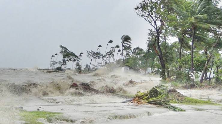
Cyclone Amphan began making landfall near the Sundarbans in West Bengal on Wednesday afternoon with a wind speed of 155 to 165kmph gusting to 185kmph as an extremely severe cyclonic storm.
It will cross the West Bengal-Bangladesh coast between Digha in West Bengal's East Midnapore district and Hatiya Island in Bangladesh, reports Hindustan Times.
"Yes it has begun landfall as an extremely severe cyclonic storm. Its trajectory is being tracked," Secretary of India's Ministry of Earth Sciences M Rajeevan Nair told Hindustan Times.
According to IMD's glossary an extremely severe cyclonic storm is considered when wind speed is between 167 to 221kmph and a super cyclone is considered when wind speed is more than 222kmph.
After the landfall, the system is very likely to continue to move north-northeastwards, across Gangetic West Bengal & Bangladesh and weaken gradually. It is likely to maintain the intensity of Cyclonic Storm till the morning of 21st May and thereafter it will weaken into a Deep Depression over Bangladesh. Under its influence gale wind speed reaching 70-80kmph gusting to 90kmph likely over interior districts (Murshidabad & Nadia) of gangetic West Bengal during 20th night to 21st morning.
As of 1pm, the super cyclone was lying 150km east-northeast of Paradip; 95km south-southeast of Digha, 90km nearly south of Sagar island and 260km west-southwest of Khepupara in Bangladesh, the IMD said.
During landfall near Sagar Island, the intensity of the cyclone is likely to be 155 to 165kmph gusting up to 185kmph.
The storm surge is expected to inundate low-lying areas of south and north 24 Parganas and parts of East Midnapore districts during landfall.
Wind speed in Kolkata, and adjoining Hooghly and Howrah districts are likely to range between 110kmph to 120kmph gusting to 130kmph that may cause extensive damage in urban areas as well.
Gale wind of 75 to 85kmph gusting to 95kmph is also likely to impact the north Odisha coast, including Jagatsignghpur, Bhadrak, Balasore, and Kendrapara districts, among others.
The cyclone is expected to cause heavy to extremely heavy rainfall over Gangetic West Bengal and heavy to very heavy rainfall over north coastal Odisha on Wednesday. It will also cause heavy to very falls over sub-Himalayan West Bengal and Sikkim on Wednesday and Thursday and Meghalaya on Thursday.
IMD is expecting extensive damage to all types of kutcha houses, some damage to old badly managed pucca structures; the potential threat from flying objects; uprooting of communication and power poles, disruption of rail/road link at several places, extensive damage to standing crops, plantations, orchards, falling of palm and coconut trees, uprooting of large bushy trees and large boats and ships may get torn from their moorings.
National Disaster Response Force (NDRF) director-general SN Pradhan said on Tuesday that all precautionary measures have been taken and people from low-lying areas evacuated.
"The biggest challenge is that we are facing two disasters together — coronavirus disease (Covid-19) outbreak and cyclone Amphan. We've been spreading awareness about both Covid-19 and the cyclone while evacuating people. If a cyclone shelter has a capacity of 1,000, we can only accommodate half of that in a bid to maintain social distancing norms," he added.
"One of the most important factors is the storm surge that comes with the landfall. IMD and Indian National Centre for Ocean Information have forecasted a storm surge of about 4-6 metres above the tidal level. This could have an impact on the coastal areas and also raise the river levels," said Roxy Mathew Koll, Climate scientist at Indian Institute of Tropical Meteorology.
Unauthorized use or reproduction of The Finance Today content for commercial purposes is strictly prohibited.